System
Light
Dark
News
RSS, last 100
Podcast feed of the last two years
SD quality
Podcast audio feed of the last year
Podcast archive feed, everything older than two years
SD quality
News
RSS, last 100
Podcast feed of the last two years
SD quality
Podcast audio feed of the last year
Podcast archive feed, everything older than two years
SD quality
Search for "openstreetmap" returned 664 results
previous page
Sort by
Newest first
Oldest first
Relevance
next page
50 min
Aufbau und Aktualisierung einer OSM-basierten Karten mit osm2pgsql
Kartographie und Visualisierung
HS4 (ZHG 008)
50 min
2026-03-26
114
Mathias Gröbe
FOSSGIS 2026
26 min
OpenStreet mal ohne Map
Freie Daten
GI Studio
26 min
2016-07-05
0
Frederik Ramm
FOSSGIS 2016
16 min
Wo sind meine Ways geblieben?
OpenStreetMap
HS3 (ZHG 009)
16 min
2026-03-27
62
Michael Reichert
FOSSGIS 2026
29 min
Kinder, Karten, Open Source
Ausbildung, Lehre, Open Science
HS1 (Aula)
29 min
2025-03-27
106
Dr. Roland Olbricht
FOSSGIS 2025
24 min
Wenn Firmen mappen
Geo
OpenStreeetMap
24 min
2019-03-14
150
Michael Reichert
FOSSGIS 2019
25 min
10 Jahre Overpass API
OpenStreetMap
Geo
25 min
2021-06-07
94
Dr. Roland Olbricht
FOSSGIS 2021
6 min
Vorstellung SOTM-EU
Allgemeines
Großer Hörsaal Geb. 308
6 min
2011-04-07
4
Manuela Schmidt
FOSSGIS 2011
37 min
Why OSM is not known more widely - about consequences of not enforcing attribution…
Community and Foundation
OSM
37 min
2021-07-11
68
Mateusz Konieczny
State of the Map 2021
26 min
Summer of Code
Freie Daten
GI Studio
26 min
2016-07-06
2
Peter Barth
FOSSGIS 2016
24 min
Photo mapping from my village to Pharmacies and Addresses
sotm2024
Mapping
24 min
2024-09-06
61
Yvonne Darko
State of the Map 2024
48 min
DG99: Offene Geodaten für den humanitären Einsatz
48 min
2019-05-14
284
Felix Delattre
CCCB Datengarten
23 min
Bezahltes Mapping – Beispiel Barrierefreie Reisekette
OpenStreetMap
HS3 (ZHG 009)
23 min
2026-03-27
87
Michael Reichert
and
Dietmar Seifert
FOSSGIS 2026
29 min
Jenseits von Mercator
Freie Daten
Audimax
29 min
2016-07-04
2
Christoph Hormann
FOSSGIS 2016
22 min
Overpass API since 10 years
Software Development
OSM
22 min
2021-07-11
63
Dr. Roland Olbricht
State of the Map 2021
26 min
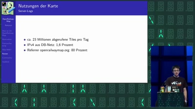
OpenRailwayMap – wie kommt das Signal auf die Karte?
Technologie, Energie und Mobilität
26 min
2024-06-01
716
Nakaner
Gulaschprogrammiernacht 22
5 min
Eröffnungsveranstaltung
Allgemeines
Aula / 4.1000
5 min
2013-06-12
18
Emmanuel Belo
,
Erich Zoller
,
Hanno Rahn
,
Hermann Mettler
,
Julius Chrobak
,
Marc Wick
,
Oliver Tonnhofer
,
Peter Körner
,
Peter Lanz
,
Petr Pridal
,
Ralph Straumann
and
Simon Poole
FOSSGIS 2013
26 min
OSM & Trails: New Collaborations for Responsible Recreation
User Experiences
OSM
26 min
2022-08-21
16
Maggie Cawley
State of the Map 2022
23 min
OSM-Daten in QGIS nutzen
Geo
OpenStreeetMap
23 min
2020-03-11
392
Astrid Emde
FOSSGIS 2020
29 min
Public Domain Map: Crowdsourcing the Future of Government Data
Software Development
OSM
29 min
2022-08-20
56
Jess Beutler
and
James McAndrew
State of the Map 2022
28 min
Dealing with Quantity vs Quality
Mapping
OSM
28 min
2021-07-11
26
Enock Seth Nyamador
State of the Map 2021
29 min
Nicht zuschauen - Mitmachen!
Vorträge (OSM)
Aula
29 min
2015-03-11
0
Frederik Ramm
FOSSGIS 2015
24 min
Parkraumdaten aus OSM mit der Verwaltung pflegen (Praxisbericht)
Praxisberichte
HS3 (S1)
24 min
2025-03-27
162
Tobias Jordans
and
Alex Seidel
FOSSGIS 2025
26 min
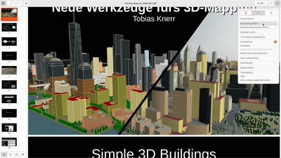
Neues von OSM2World
Vorträge (OSM)
H3
26 min
2014-03-19
2
Tobias Knerr
FOSSGIS 2014
29 min
Karten auf Stoff: OSM Daten mit OSGeo Software
Vorträge (OSM)
H3
29 min
2014-03-20
14
Arnulf Christl
FOSSGIS 2014
5 min
Über 1000 Apps in 5 Minuten - Der OSM Apps Catalog
OpenStreetMap
HS4 (ZHG 008)
5 min
2026-03-26
199
Christopher Lorenz
FOSSGIS 2026
previous page
next page