System
Light
Dark
News
RSS, last 100
Podcast feed of the last two years
SD quality
Podcast audio feed of the last year
Podcast archive feed, everything older than two years
SD quality
News
RSS, last 100
Podcast feed of the last two years
SD quality
Podcast audio feed of the last year
Podcast archive feed, everything older than two years
SD quality
Search for "openstreetmap" returned 664 results
previous page
Sort by
Newest first
Oldest first
Relevance
next page
17 min
Barrierefreies Routing mit MOTIS
Neuigkeiten und Interessantes aus den Open-Source-Projekten
HS2 (S10)
17 min
2025-03-27
161
Felix Gündling
FOSSGIS 2025
21 min
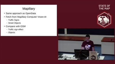
Osmose-QA : MapCSS, OpenData and Mapillary
Software Development
StateoftheMap
21 min
2019-09-23
59
Frédéric Rodrigo
State of the Map 2019
29 min
Taginfo
Vorträge (OSM)
Kleiner Hörsaal Geb. 308
29 min
2011-04-07
2
Jochen Topf
FOSSGIS 2011
23 min
OSM-History-Analysen auf Basis von Big-Data-Technologie
Freie Daten
23 min
2017-03-22
8
Martin Raifer
FOSSGIS 2017
27 min
OSM2World: Updates für den 3D-Pionier
OpenStreetMap
HS3 (S1)
27 min
2025-03-28
165
Tobias Knerr
FOSSGIS 2025
38 min
Lightning Talks I
Community and Foundation
OSM
38 min
2021-07-09
110
SotM Working Group
State of the Map 2021
6 min
Preis der Karte
Geo
OpenStreeetMap
6 min
2019-03-13
538
Alexey Valikov
FOSSGIS 2019
25 min
Erwartete Qualitätssicherung
OpenStreetMap
HS3 (ZHG 009)
25 min
2026-03-27
61
Dr. Roland Olbricht
FOSSGIS 2026
19 min
World-Map-Explorer – Explore the world with ease
Software Development
Mayon
19 min
2025-10-04
24
Manoj Karingamadathil
State of the Map 2025
54 min
Kartographische Generalisierung mit PostgreSQL und PostGIS
Kartographie und Visualisierung
54 min
2023-03-15
512
Mathias Gröbe
and
Robert Klemm
FOSSGIS 2023
36 min
OSM-Quiz
Wie gut kennst du OSM?
Freie Daten
36 min
2017-03-23
9
Peter Barth
FOSSGIS 2017
27 min
What Could You Do with 100 Days of Mapping?
Mapping
Mayon
27 min
2025-10-05
14
Laura Mugeha
State of the Map 2025
25 min
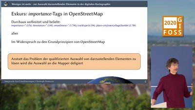
Weniger ist mehr - zur Auswahl darzustellender Elemente in der digitalen Kartographie
Geo
OpenStreeetMap
25 min
2020-03-11
163
Christoph Hormann
FOSSGIS 2020
29 min
Mapping für einen sozialen Zweck
Vorträge (OSM)
Kleiner Hörsaal Geb. 308
29 min
2011-04-06
0
Holger Dieterich
FOSSGIS 2011
19 min
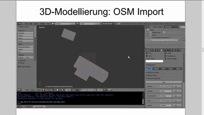
Blender-basierte Erstellung von 3D-Modellen von Orten mit Hilfe von OSM-Daten
Vorträge (OSM)
H3
19 min
2014-03-19
10
Vladimir Elistratov
FOSSGIS 2014
31 min
GIS Lightning Talks 1
Freie Daten
Audimax
31 min
2016-07-04
0
FOSSGIS 2016
28 min
Mach mit – Erfassung von Daten zur Barrierefreiheit im ÖPNV
Vortrag
28 min
2023-03-12
100
Robin Thomas
Chemnitzer Linux-Tage 2023
16 min
MapaTanda: Mapping for and with the Ageing Population
Community and Foundation
OSM
16 min
2021-07-09
19
Kris Libunao
State of the Map 2021
36 min
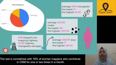
Gender Performance in OSM Mapping, Does It Matter?
User Experiences
36 min
2020-07-05
42
Zainab Ramadhanis
State of the Map 2020
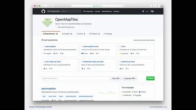
22 min
OpenMapTiles
Revolution in selbstgehosteten Karten
22 min
2018-03-22
482
Petr Pridal
FOSSGIS 2018
28 min
MoNav & OSRM: 1 Jahr später
Vorträge (OSM)
Kleiner Hörsaal Geb. 308
28 min
2011-04-06
0
Christian Vetter
and
Dennis Luxen
FOSSGIS 2011
49 min
Opening
Community and Foundation
Apo
49 min
2025-10-03
28
SotM Working Group
State of the Map 2025
28 min
OSM Swiss Style and the new OSM Swiss Base Map
Cartography
Pulag
28 min
2025-10-04
57
Stefan Keller
State of the Map 2025
28 min
State of Independence
Community and Foundation
OSM
28 min
2022-08-19
189
Richard Fairhurst
State of the Map 2022
25 min
Flexible Routenplanung mit GraphHopper
Freie Daten
GI Studio
25 min
2016-07-05
4
Peter Karich
FOSSGIS 2016
previous page
next page