System
Light
Dark
News
RSS, last 100
Podcast feed of the last two years
SD quality
Podcast audio feed of the last year
Podcast archive feed, everything older than two years
SD quality
News
RSS, last 100
Podcast feed of the last two years
SD quality
Podcast audio feed of the last year
Podcast archive feed, everything older than two years
SD quality
Search for "openstreetmap" returned 664 results
previous page
Sort by
Newest first
Oldest first
Relevance
next page
28 min
Braucht OpenStreetMap Flächen und Kanten?
Freie Daten
GI Studio
28 min
2016-07-04
4
Roland Olbricht (drolbr)
FOSSGIS 2016
25 min
Lügen mit Statistik, OpenStreetMap-Edition
Missverständnisse und Fehlinterpretationen mit OSM-Metadaten
25 min
2018-03-22
512
Frederik Ramm
FOSSGIS 2018
84 min
Winds of Change in OpenStreetMap
Community and Foundation
84 min
2020-07-04
599
Allan Mustard
State of the Map 2020
34 min
OpenStreetMap-Daten ohne Datenbank verarbeiten
34 min
2018-03-24
379
Thomas Skowron
FOSSGIS 2018
28 min
Von OpenStreetMap zu semantisch vernetzten Wissensgraphen
Daten, Datenbanken und Datenprozessierung
HS2 (ZHG 010)
28 min
2026-03-26
67
Florian Thiery
FOSSGIS 2026
48 min
Mit OpenStreetMap digital souverän Ideen verwirklichen
Vortrag
V2
48 min
2026-03-29
164
Falk Zscheile
Chemnitzer Linux-Tage 2026
27 min
OpenStreetMap x Wikidata Collaboration: Taiwan Case
Mapping
Mayon
27 min
2025-10-04
20
Dennis Raylin Chen
State of the Map 2025
29 min
Radnetz-Qualität mit OpenStreetMap-Daten auswerten
Daten, Datenbanken und Datenprozessierung
29 min
2024-03-22
881
Alex Seidel
FOSSGIS 2024
26 min
Parkraumanalyse für deine Stadt mit OpenStreetMap
Praxisberichte
26 min
2023-03-16
288
Tobias Jordans
,
Lars Lingner
and
Alex Seidel
FOSSGIS 2023
44 min
How to become an OpenStreetMap pro
R3S - Remote Rhein Ruhr Stage
FireShonks
44 min
2022-12-29
1.3k
jomo
Dezentrale Jahresendveranstaltungen
40 min
OpenStreetMap Standard Layer: Who uses it?
Community and Foundation
OSM
40 min
2021-07-10
83
Paul Norman
State of the Map 2021
4 min
Soziale Medien, dezentrale Netzwerke und OpenStreetMap
Open Data und Lizenzen
Geo
4 min
2021-06-07
68
pukkamustard
FOSSGIS 2021
26 min
Nicht nur Kinderwagen-Routing mit OpenStreetMap
OpenStreetMap
Geo
26 min
2021-06-08
98
Dr. Roland Olbricht
FOSSGIS 2021
20 min
mapillary2osm: OpenStreetMap Data from Computer Vision
20 min
2019-08-28
185
Edoardo Neerhut
FOSS4G 2019
27 min
Introduce OpenPlaceReviews and connect to OpenStreetMap
Software Development
StateoftheMap
27 min
2019-09-23
101
Victor Shcherb
State of the Map 2019
27 min
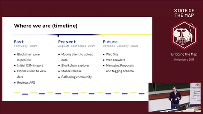
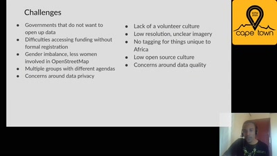
The State of OpenStreetMap in Africa
Community and Foundation
27 min
2020-07-04
107
Geoffrey Kateregga
State of the Map 2020
57 min
OpenStreetMap, the free Wiki world map
3 years done - 10 to go?
57 min
2007-12-29
113
Frederik Ramm
24C3: Volldampf voraus!
24 min
OpenStreetMap an die (Schul-)Wand hängen
Vorträge (OSM)
H3
24 min
2014-03-20
6
Lars Lingner
FOSSGIS 2014
24 min
OpenStreetMap- und ALK-Daten gemeinsam nutzen
Vorträge (OSM)
3.008
24 min
2013-06-13
0
Dominik Helle
FOSSGIS 2013
28 min
Automatische Edits und Importe in OpenStreetMap
Freie Daten
GI Studio
28 min
2016-07-04
0
Frederik Ramm
FOSSGIS 2016
45 min
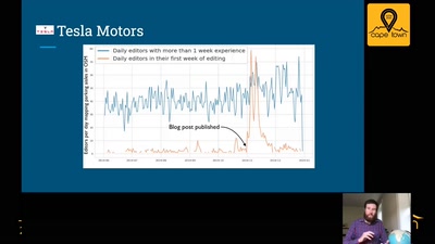
Curious Cases of Corporations in OpenStreetMap
OSM
45 min
2020-07-05
454
Jennings Anderson
and
Dipto Sarkar
State of the Map 2020
29 min
Wer ist der Boss bei OpenStreetMap?
Vorträge (OSM)
3.008
29 min
2013-06-12
6
Frederik Ramm
FOSSGIS 2013
24 min
Data Science with OpenStreetMap and Wikidata
General
24 min
2019-08-29
383
Nikolai Janakiev
FOSS4G 2019
11 min
Making OpenStreetMap More Accessible for New Mappers
Community and Foundation
Pulag
11 min
2025-10-04
16
Brazil Singh
State of the Map 2025
24 min
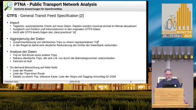
PTNA: Qualitätssicherung für ÖPNV-Linien in OpenStreetMap
OpenStreetMap
HS1 (Aula)
24 min
2025-03-28
185
Toni Erdmann
FOSSGIS 2025
previous page
next page